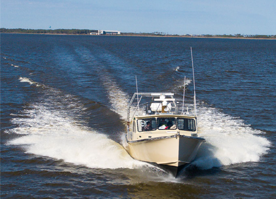
Row, Row, Row Your Boat, Gently Down the (Gulf) Stream: “The Duffy”
Miss Caroline may not win a beauty pageant, but as far as Dr. Michael Muglia (Assistant Research Professor) is concerned, she is a sight to behold. He first laid eyes on her in Noank, a small seaside village in the town of Groton, Connecticut. Dr. Muglia was instantly smitten and knew she was “the one.” He promptly arranged for Miss Caroline to leave her home on the Mystic River and begin a new, exciting life in Wanchese, NC.
Miss Caroline is CSI’s research vessel. She is a Duffy, a boat known for excellent seaworthiness and a brand revered and long-established in the marine industry. With offshore, nearshore, and inshore capabilities, and some serious after-market add-ons, she meets all of Dr. Muglia’s and his NC Renewable Ocean Energy Program (NCROEP) team’s needs while conducting research on the high seas. The boat has been upgraded with an A-frame, a hydraulic deck winch with 2000 lb. capacity, 1000 hp Caterpillar diesel engine, custom through-hull Acoustic Doppler Current Profiler (ADCP) compartments, and an equipment-launching sled. And despite the added weight of these extra components, the vessel zips along at a cruising speed of 17 knots.

An ADCP is a critical tool for determining information about the biological, chemical, and physical properties of the ocean. The device uses sound waves to measure the speed and direction of currents throughout the water column. The 75 and 300-kilohertz ADCPs installed on the Miss Caroline can make continuous measurements while steaming. There are also onboard computer servers that operate the instruments and archive observations, continuous salinity, and temperature measurements from the boat dock at CSI, all the way across the Gulf Stream.
The custom-designed A-frame structure allows for deploying and recovering scientific instruments such as buoys, bottom instrumented pods, and anchors. Features like this have led to Miss Caroline earning quite the reputation as an intrepid research vessel. Dr. Muglia fields inquiries from outside organizations clamoring for the opportunity to collaborate on projects. Miss Caroline can deliver scientists and their equipment to the Gulf Stream in a few hours at a relatively low cost and can maneuver through the shallow waters of Oregon Inlet.
Dr. Muglia recalls the early, adventurous days of the NCROEP relying on a 28-foot Privateer to ferry researchers across the deep depths of the Atlantic Ocean, collecting observations along an eight-mile transect near the edge of the continental shelf. The safety and stability that Miss Caroline provides is a welcome and appreciated upgrade.
“It’s not much to look at,” says Dr. Muglia, “but it’s a tank to work on.” He declares his best days are spent with his crew, surrounded by the mesmerizing beauty of the ocean, learning evermore about the fascinating Gulf Stream current, aboard the Miss Caroline – a real dreamboat.
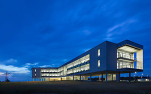
A Meeting (Place) of the Minds: Student Collaboratory
Colorful collegiate collaboratory. Try saying that three times fast! This tongue twister describes the newly reconfigured space that thoughtfully addresses students’ needs outside of the traditional classroom setting. It is a place where, unlike individual learning, students can collaborate and capitalize on their classmates’ unique resources and skills, where they interact by sharing experiences. Here, peer relationships are fostered, different perspectives are introduced and considered, and critical thinking skills are honed.
It is a welcoming environment where students can relax, socialize, and develop their interpersonal skills and their self-awareness. Here, they can engage with each other, working in pairs or small groups to discuss concepts, share ideas, work on team projects, and find solutions to problems.

There are multiple desktop computers for easy access to continue research and information gathering and wide screen TVs for virtual meetings or for viewing entertaining or instructional videos.
A wall of windows floods the room with natural light and offers a stunning view of the surrounding marsh and the Croatan Sound. Bright, comfortable furniture invites the opportunity for reflection or a stimulating conversation. An inspiring setting and space where students can take a breather, search for understanding, learn from one another, develop the next critical coastal research instrument, and enjoy spending time together in the process. Proving that some of the best collaborations occur outside of the classroom.
Sounds Geek to Me: Coastal Computational Lab
Incoming! Giant data sets!
Bring it on! The new Coastal Computational Lab can handle it. We’re talking eight high-processing computer workstations featuring Dual 8-core Xeon processors with enough computational power to analyze massive, complex data sets and to parse complex numerical models. Each computer connects into a dedicated 10 Gigabit network for access to a centralized multi-terabyte storage system. Researchers will utilize this fast link for seamless upload and immediate backup of critical field data. For example, 20 Gigabytes of data can be safely secured from an external drive within 2.5 minutes. Collaboration is a (coastal) breeze in this geeked-out work environment!
With our new computing capability providing optimum application performance, the portfolio of software applications reads like something in a spy novel: XBeach, SWAN, Delft3D, CH3D, SEDZLJ, MATLAB, SPSS, R, ArcGIS, etc. CSI Researchers will swiftly clue in on new insights, approaches, and solutions; form accurate predictive models; and deliver informed decisions. Processing and interpreting such a broad mix of data and imagery generated by these programs would be nearly impossible, or at the very least frustratingly cumbersome, using traditional methods.

Eager to put the souped-up computer system through its paces, their ambitious project to-do list includes the study of such topics as the effects of beach evolution on nesting sea turtles, assessing shoreline and coastal change, coastal hazard modeling, sediment movement, understanding the beneficial use of dredge-spoil for marsh restoration, and quantifying spatial variations in the effect of mangrove forests for flood risk reduction.
The lab is outfitted with ergonomic chairs in bright shades and desks separated by upholstered panels to offer a bit of sound muffling and privacy. Whether researchers choose to focus and work individually or prefer to interact and collaborate among other lab users, the space is conducive to both. PhD students, postdoctoral scholars, and research associates at CSI are welcome to utilize the lab as well.
Bonus: Investing in this upgraded technology provides researchers with an edge when applying for competitive grants that require such efforts. Now, that’s a win-win!
What on Earth? Terrestrial Laser Scanner
How about placing an order of the beach “to go?” Using a Terrestrial Laser Scanner (TLS), Dr. David Lagomasino (Assistant Professor, Department of Coastal Studies) can scan an entire section of the beach in a matter of seconds and create a 3-D computer model so detailed it shows tire tracks and footprints. Would you like sunscreen with that?
Excited by this amazing technology, Dr. Lagomasino says, “Really I have taken the beach home with me and put it on the computer.”
The TLS is a powerful tool that collects high-resolution and high-accuracy data for topographic and morphological studies. Using laser beams, advanced sensors, Global Positioning Systems (GPS), Inertial Measurement Units (IMU), receiver electronics, and photodetectors, laser scanners collect information in the form of point cloud data which consists of millions of 3D coordinates. When the point cloud data are processed, they form a digital representation of the scanned surfaces, structures, and landscapes, demonstrating the dimensions and spatial relationships of topographic features and structures in full living color.


Laser scanning is fast and reduces the time and human effort needed to complete surveys. For surveying vast landscapes, laser scanning systems can be mounted onto land-based or aerial vehicles. With vehicle-mounted or drone systems, point cloud data can be gathered from even the most inaccessible or dangerous areas.
Dr. Lagomasino’s utilization of the TLS in his study of coastal resilience and vulnerability helps provide him with meaningful information, resulting in improved understanding and innovative techniques to influence coastal management practices. It is a handy device to have in this researcher’s toolbox.
Remote Possibilities: The Z-Boat
At first glance, the Z-Boat looks like the coolest toy you ever hoped for. With its sunny yellow hull and diminutive size, it’s easy to imagine a couple of action figure passengers aboard, enjoying a cruise around the harbor. Although the fun factor can’t be denied, the Z-Boat is a powerful research apparatus capable of providing significant assistance in data gathering. With its single-beam echo sounder using sonar technology to transmit sound waves, the vessel provides bathymetric surveys – the measuring of water depths.

This unmanned aquatic drone can be controlled via remote control or, alternatively speaking, the vessel can be given a pre-programmed route in a specific area to follow autonomously. Allowing the boat to accomplish its task independently eliminates the painstaking task of steering it in a certain route for hours, thus freeing up time to complete other project work. This feature is also beneficial for projects that involve long-term (multi-hour) deployments. The remote-control attribute is useful for precise maneuvering and allows for quick and easy data collection when the area being surveyed is less extensive.
The Z-Boat allows for easy and safe surveying/data collection in areas closest to the shore, shoals, and rocks. In most cases, due to safety concerns, these places do not have recorded depth measurements as they are shallow, difficult to navigate, and potentially dangerous for traditional modes of surveying. This vessel is highly maneuverable and able to navigate close to piers, pilings, and the shoreline. The Z-boat has proven to be particularly helpful on the sound side of Pea Island, an area that is quite shallow and tricky to navigate, even with a Jet Ski.
The time and effort required to deploy a boat can be avoided as researchers stay safe and dry on shore while this spunky little vessel travels through the waterways for a quick or large-scale survey. Which leads us to say, the Z-Boat is Z-Best!
 ECU's Integrated Coastal Programs (ECU ICP) is a leader in coastal and marine research, education, and engagement. ECU ICP includes the Coastal Studies Institute, ECU's Department of Coastal Studies, and ECU Diving and Water Safety.
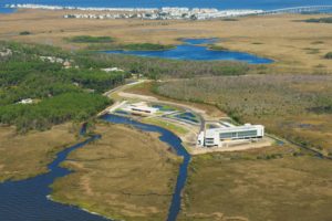 The ECU Outer Banks campus is home to the Coastal Studies Institute.

